No. 5. Waiwhetu (Colonel McCleverty's Deed)
WAIWHETU BLOCK (COLONEL MCCLEVERTY'S DEED), WELLINGTON DISTRICT.
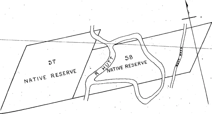
"Number two plan" map
30 August, 1847.
Exchange for other lands
Ko matou ko nga tangata o Waiwhetu, ko nga tangata i a matou nga tae kai me etahi whenua ano. Ka whakaae inaianei i te toru tekau o nga ra o Akahuta i te tau o to tatou Ariki Kotahi mano e waru rau e wha tekau ma whitu kia tukua whakareretia atu a matou mahinga kai katoa e takoto ano i waenganui o nga wenua o nga pakeha i roto ranei o Heretaunga, i tai ranei, i roto tonu katoa o Poneke, hei utu mo te Whenua ka oti nei te homai mo matou e te Kanara (Lieutenant Colonel McCleverty) e ratou ko nga Kawana, kua whakaaetia nei e matou, kua kite iho nei o matou kanohi, kei roto o Heretaunga, he mea ta ki te kara whero i roto o te pukapuka tuatahi ko to te pukapuka tuarua he mea ta ki te kara kowhai - kei te pukapuka e takoto ake nei te tohu.
Kei te pukapuka tuatahi, koia ia ko te wenua i roto o Whaiwetu 19 te Whika, ko te whenua o Hanita ko te kaha ki te hau raro ko te wenua i te 23 o nga Whika ko te kaha ki te tonga ko nga Maunga - ko te kaha ki te tonga hauauru, ko nga ara ruri - ko te ara ki te tonga, hei rohe atu i te 13, i te 14 o nga pihi Whenua ko te ara ki te mauru hei rohe atu i te 18 o nga pihi whenua huihuia nga ekara o te mea mo matou kotahi rau e ono ekara - nui ake ranei - iti iho ranei kei te pukapuka tuarua koia ia ko tetehi wahi o te 57, ko tetehi wahi o te 18 o nga pihi whenua i te Taita. Ko te kaha ki te hauraro, ko te 60 o nga pihi whenua - ki te tonga, ko te awa o Heretaunga. Ko te 59 hoki o nga pihi whenua - ki te mauru ko nga maunga te kaha mai - ko nga ekara i riro mai mo matou o roto o te 57 o nga pihi - 125 ekara - ko nga ekara i riro mai i te 58 o nga pihi, 15 ekara - kei roto enei kei te tuarua o nga pukapuka - huihuia 140 ekara - kei roto kei te pukapuka tuatahi 106 ekara - huihuia katoatia nga ekara i riro mai mo matou 246 o nga ekara. [Boundaries 246 acres].
Ko HakopaKo HamueraKo WirikiKo KarenaKo Rihia signs forKo AkaripaKo Tangathese himselfKo HowaiaKo Puru HareKo WenaKo HenereKo HohepaKo RihiaKo TawaiTe Kepa
Te tohu x Te RetutuTe tohu x Nga KirikiriTe tohu x Te HapimanaTe tohu x Te Tereturuturu te AongoTe tohu x HoroparperaTe tohu x Nga HengaTe tohu x Te Matahiwi.Te tohu x Te ManiheraRihia signs for the above.
Rihia signs for these threeKo Hare Wiremu.
Ko te Hotene.
Ko Rameka.
Witnesses to the signatures on the day above written: -
W.A. McCleverty, Lt. Colonel
T.H. Fitzgerald, Sur.
S.M. Scroggs, Asst. Sur.
W. Duncan, Interpreter.
English translation
We the Landholders and Chiefs residing at and belonging to Waiwetu on the River Hutt, agree on the thirtieth day of August one thousand eight hundred and forty seven to give up to Her Majesty's Government all those cultivations which we have hitherto had on sections in the Harbour and Hutt Districts or elsewhere belonging to European settlers on our receiving from Lieutenant Colonel McCleverty, subject to the approval of the Governor or Lieutenant Governor, portions of land which we have seen and agree to receive in the Hutt District; a plan of which portions as coloured Red in Number (one) "1" and yellow in number (two) "2" and as hereinafter described accompanies this.
Number (one) "1" is the plan of section number nineteen "19" in the Lower Hutt or Waiwetu District formerly belonging to Messrs Bethune and Hunter. Bounded on the North by number twenty three "23" of the same District, on the East by the Hills westerly of the Waiwetu river, on the South and west by the roads marked on the plan of the said District, that on the South dividing it from sections number thirteen "13" and fourteen "14" of said District, and that on the West from section number eighteen "18" containing one hundrend and six acres of thereabouts.
Number two "2" is nearly the whole of section number fifty seven "57" of the Lower Hutt and part of Number fifty eight "58" in the same District. It is bounded on the North by section number sixty "60" on the East by the River Hutt and section "56" and on the East by the Hills westerly of the River Hutt.
The portion of No. 57 contains ... ... ... ...125 acresDitto. No. 58 contains ... ... ... ...15 acresIn No. 2 plan ... ... ... ...140 acresIn No. 1 plan ... ... ... ...106 acres246 acres
The natives of Waiwetu are also guaranteed in their pah - plan of which is annexed coloured red containing 3 acres 2 roods 39 perches (3a. 2r, 39p)
13 September, 1847. W.A. McC.
In addition E Puni relinquishes any claim to a portion of Native Reserve no. 20 Lower Hutt District near the Bridge to the Waiwetu Natives as shown in the plan and deed of No. 1 Petoni.
W. A. McCleverty, Lt. Col.
No. 94. Received for Registration at 11 o'clock a.m. 11th March, 1848. Robert Strang, Registrar of Deeds.
A true copy of Original Deed, Maori translation, and Endorsement.
H. Hanson Turton.
Wellington, January 15th, 1876.